Secure Tenure on Zanzibar
March 21, 2023Transforming Data Accessibility Through Location-Based Engagement
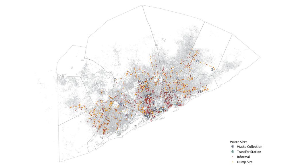
June 26, 2023Last year, we collaborated with Humanitarian OpenStreetMap Team and OSM Somalia to generate high-quality geographic data aimed at comprehending the extent and dispersion of solid waste sites in Mogadishu.
Managing solid waste is a multifaceted and intricate problem that necessitates a thorough comprehension of the ecosystem, involving various actors and factors such as social, economic, governance, environmental, cultural, and technological processes. Therefore, we carried out a mixed-method approach comprising a combination of quantitative and qualitative data collection methods to capture all pertinent data.
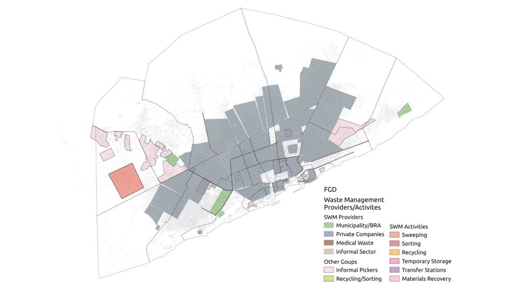
The digitization of satellite imagery played a pivotal role in this approach, providing a base layer for all other datasets. All buildings in Mogadishu were digitized. The digitized buildings, coupled with satellite imagery, served as a foundation for Focus Group Discussions (FGDs) held with representatives of 17 districts in Mogadishu. These FGDs enabled the identification of people’s perceptions, concerns, and ideas in a spatial context. The resulting data was used to develop detailed maps pinpointing areas that necessitate attention and intervention. The FGDs were complemented by Key Informant Interviews (KIIs) that provided valuable insights into the waste management ecosystem in Mogadishu. KIIs gathered top-down perceptions from formal governance actors, while FGDs captured the opinions and experiences of both formal and informal governance actors such as local government officials, community leaders, citizens, and even garbage pickers. This comprehensive approach allowed for a better understanding of the issue, and the resulting data can be used to develop effective policies and strategies that take into account the needs and experiences of all stakeholders.

Waste management providers and activities in Mogadishu gathered through the Focus Group Discussions
Data verification was carried out through field visits and mobile data collection to ensure that the data collected was accurate and dependable. This validation ensured that the data collected through KIIs and FGDs, and the resulting analysis and maps, were based on trustworthy data.
Finally, all the data were merged for further analysis and map creation. The resulting maps and analysis provide a comprehensive understanding of the waste management ecosystem in Mogadishu and can be utilized to develop targeted policies and strategies that address the specific needs and challenges of the city.
In summary, the mixed-method approach adopted for mapping waste in Mogadishu provided a comprehensive and detailed understanding of the issue, and the resulting data can be used to develop effective policies and strategies that enhance waste management practices in the city.
Finally, hats off to the OSM Somalia members who carried out the fieldwork, sometimes under very challenging conditions! Their dedication is truly commendable.

Field data collection


